Yosemite National Park is one of our favorite national parks. It was the first national park I visited as an adult, and the magic of your first always stays with you. Back then I didn’t even know what a national park was, and only vaguely remember childhood road trips. Now we’ve visited over 30 and hope to visit them all by the end of the year.
Over the years, Yosemite has become popular and overcrowded, but one of the best ways to avoid the bulk of the crowds is by simply getting onto the trails! To help you plan your trip, we’ve compiled a list of the best hikes in Yosemite National Park and then a complete list of hikes below that.
 Pin
PinThis post may contain affiliate links, where we receive a small commission on sales of the products that are linked at no additional cost to you. All opinions are always our own. Read our full disclosure for more info. Thank you for supporting the brands that make Eearth Travel possible.
Last Updated: September 8, 2022
If you are visiting between May 20th and September 30th, you will need to make an advanced reservation to enter the park.
11 BEST HIKES IN YOSEMITE NATIONAL PARK
Trailhead Coordinates: 37.7331223,-119.5538239, map
Distance: 15.35 miles, round trip
Elevation Gain: 4,800 feet
Difficulty: Strenuous
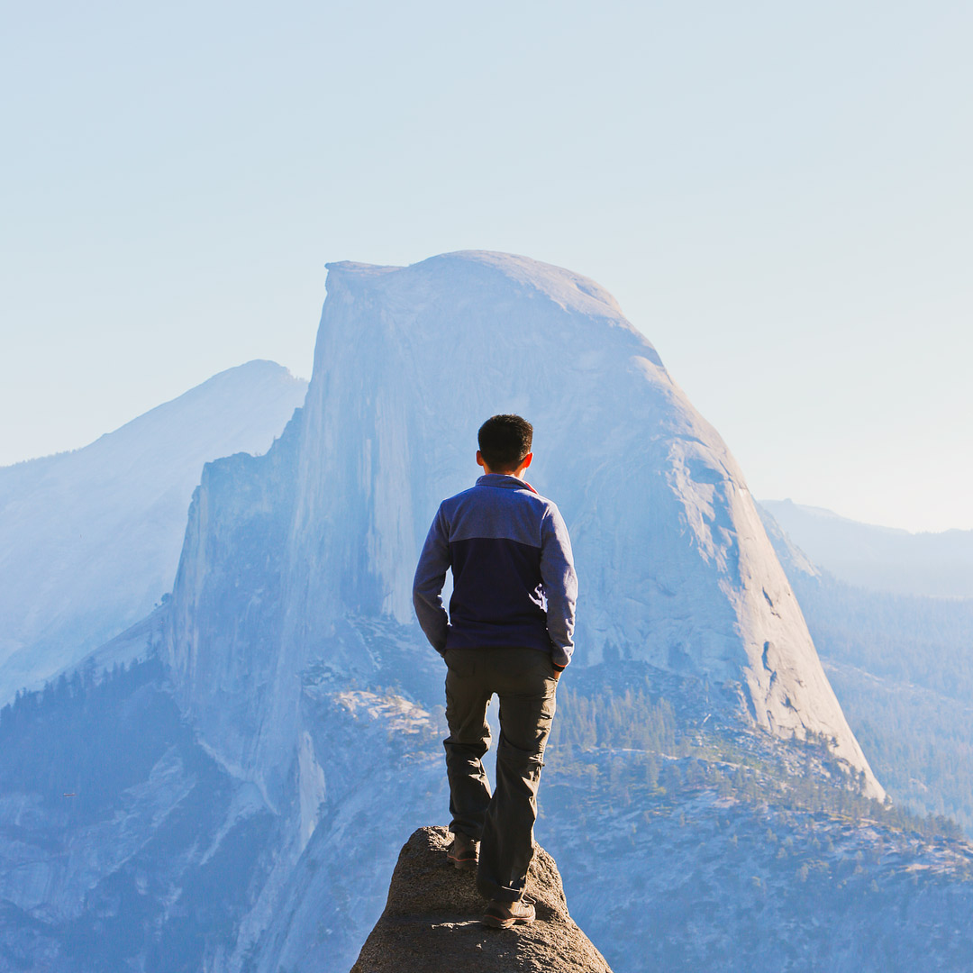
You see Half Dome from the most iconic views in the valley like Tunnel View and Glacier Point. This is the bucket list hike everyone wants to do and part of the John Muir Trail. Because of its popularity, it’s difficult to get a permit, but if you get lucky, you should absolutely go for it.
You get amazing views during the hike and if that’s not enough for you, you get the thrill of going up the cables from sub dome to half dome. The sheer sight of it from sub dome had me paralyzed. It took me half an hour to muster up the courage, and to this day, I remember it being scarier than any other hike we’ve done or even rock climbing.
To plan for the hike, check out our packing list and photo diary. It’s definitely a strenuous hike even one way, so to do the hike, you should be well prepared.

2. Mist Trail
Trailhead Coordinates: 37.7331223,-119.5538239
Distance: 3 miles, round trip
Elevation Gain: 1,000 feet
Difficulty: Strenuous
Even if you can’t get a permit for Half Dome, you should check out Mist Trail, which is the first portion of the hike on the way to Half Dome. Although it isn’t a very long hike, you see some of the best scenery.
You also climb stone steps to see the 317-foot Vernal Falls, which soaks you in spring and early summer. When the sun is just right, you also get rainbows in the mist.
 Pin
Pin Pin
Pin3. Nevada Fall
Trailhead Coordinates: 37.7331223,-119.5538239
Distance: 7 miles, round trip
Elevation Gain: 1,900 feet
Difficulty: Strenuous
If you’re just getting warmed up when you reach the top of Vernal Fall, then keep going to the top of the 594-foot Nevada Fall. You weed out a lot of the crowds that make it to Mist Trail and you can even dip your feet in at the top of Nevada Fall.

4. Four Mile Trail
Trailhead Coordinates: 37.7338125,-119.6039596
Distance: 9.6 miles, round trip
Elevation Gain: 3,200 feet
Difficulty: Strenuous
The Four Mile Trail takes you from the valley floor to the Glacier Point visitor center. After you climb above the tree lines about a mile in, you’ll start to get various viewpoints as you continue up the switchbacks.
As you reach the top, you get a straight-on shot of Yosemite Falls, and views of Sentinel Dome, El Capitan, and Half Dome. You can also make this a one-way hike by taking the Glacier Point shuttle back down (or up, and hike down, which is much easier).
5. Upper Yosemite Falls Trail
Trailhead Coordinates: 37.7338125,-119.6039596
Distance: 7.2 miles, round trip
Elevation Gain: 2,600 feet
Difficulty: Strenuous
This is one of the oldest trails in the park. It was built in the 1870s, and it takes you to the top of the continent’s tallest waterfall at 2,425 feet. You can make the hike 8.4 miles and 2,900 feet by continuing onto Yosemite Point, which is the highest point on the North Rim, to get views of Half Dome and Eagle Peak.
It’s been years since I’ve done this hike, but I still remember how excited I would get at every viewpoint. It just got better and better.

6. Cathedral Lakes
Trailhead Coordinates: 37.8732658,-119.3849332
Distance: 8 miles, round trip
Elevation Gain: 1,300 feet
Difficulty: Moderate
Hike to both Lower and Upper Cathedral Lake and enjoy views of Cathedral Peak from both. The hike starts at 8,600-foot elevation, so be prepared to get some altitude!

7. Mono Pass
Trailhead Coordinates: 37.8910012,-119.2646511
Distance: 8 miles, round trip
Elevation Gain: 1,300 feet
Difficulty: Moderate
This is a great hike that takes you to the edge of the park, and even a bit beyond it. Along the way, see ruins of log cabins from the 1879 gold and silver boom, Summit Lake and Sardine Lake, and end the trail with eagle eye views of Mono Lake.

8. Glen Aulin Trail
Trailhead Coordinates: 37.8790432,-119.3693086
Distance: 8 miles, round trip
Elevation Gain: 800 feet
Difficulty: Strenuous
Follow the Tuolumne River and eventually come across Tuolumne Falls and White Cascade, which is a great place to swim in June and July. If you haven’t gotten your fill of waterfalls yet, keep hiking up to 18 miles round trip to see California Falls, LeConte Falls, and Waterwheel Falls.
9. Clouds Rest
Trailhead Coordinates: 37.82585, -119.47046
Distance: 14.5 miles, round trip
Elevation Gain: 3,113 feet
Difficulty: Strenuous
Half Dome is definitely a bucket list hike, but it’s crowded and not always the best view. The best views have Half Dome in them, and Clouds Rest has an amazing view of Half Dome along with North Dome, El Cap, and Glacier Point. Plus, it’s more enjoyable with fewer hikers.

10. North Dome
Trailhead Coordinates: 37.8065968,-119.5474975
Distance: 9.1 miles, round trip
Elevation Gain: 1,742 feet
Difficulty: Strenuous
This hike takes you right across Half Dome, making it one of the best views in the park. Along the way, you will see amazing meadows and even a rare granite arch called Indian Arch. If you’re hoping to enjoy the views during sunrise or sunset, there are even campsites right near the dome.

11. Mirror Lake
Trailhead Coordinates: 37.739343,-119.5619597
Distance: 2.3 miles, loop
Elevation Gain: 147 feet
Difficulty: Easy
This easy and popular trail takes you to a lake with beautiful reflections. If you visit early in the summer, there are also tons of wildflowers.

Yosemite Hikes Map
More Hikes in the Park From Easy to Difficult
Yosemite Valley Area
- Happy Isles (0.5 miles, △10 feet, easy)
- Bridalveil Falls (1.2 miles, △200 feet, easy)
- Lower Yosemite Falls (0.5 miles, △50 feet, easy)
- Mirror Lake Yosemite & Tenaya Canyon (2.4 miles, △147 feet, easy)
- Sentinel / Cook’s Meadow Loop (2.25 miles, △10 feet, easy)
- Turtleback Dome (1.2 miles, △360 feet, easy)
- Artists Point (2 miles, △500 feet, easy)
- Vernal Fall Footbridge (2 miles, △300 feet, moderate)
- Inspiration Point (2.6 miles, △1,000 feet, moderate)
- Yosemite Valley Loop Trail (11.5 miles loop, △50 feet, moderate)
- Columbia Rock (3 miles, △1,000 feet, moderate)
- The Mist Trail (3 miles, △1,000 feet, moderate)
- 4-Mile Trail (4.7 miles, △3,200 feet, strenuous)
- Pohono Trail (13 miles, △3,700 feet, strenuous)
- Snow Creek Trail (7.2 miles, △2,700 feet, strenuous)
- Upper Yosemite Falls (7.6 miles, △2,600 feet, strenuous)
- Half Dome (15.35 miles, △4,800 feet, strenuous)
Southern Yosemite Area
- Wawona Swinging Bridge (0.75 miles, △50 feet, easy)
- Wawona Meadow Loop (3.5 miles, △50 feet, easy)
- Mariposa Grove of Giant Sequoias (2.2 miles, △1,200 feet, easy)
- Chilnualna Falls (8.4 miles, △2,300 feet, strenuous)
Glacier Point Road Area
- Washburn Point (0.1 miles, △15 feet, easy)
- McGurk Meadow (1.8 miles, △100 feet, easy)
- Glacier Point (1 mile round trip, △50 feet, easy)
- Westfall Meadow (2.8 miles, △100 feet, easy)
- Mono Meadow (1.2 miles, △300 feet, easy)
- Sentinel Dome Trail (2.2 miles, △400 feet, easy)
- Taft Point and the Fissures (2.2 miles, △200 feet, easy)
- Bridalveil Creek (5.5 miles, △100 feet, moderate)
- Illilouette Falls (4 miles, △1,400 feet, moderate)
- Panorama Trail Yosemite (8.5 miles, △3,200 feet, moderate)
- 4-Mile Trail (4.7 miles, △3,200 feet, strenuous)
- Dewey, Crocker, & Stanford Points (7.8 miles, △300 feet, strenuous)
- Ostrander Lake (12.4 miles, △1,600 feet, strenuous)
- Pohono Trail (813 miles, △3,700 feet, strenuous)
Tioga Road Area
- Tuolumne Meadows (2 miles, △0 feet, easy)
- Olmsted Point (0.25 miles, △100 feet, easy)
- Pothole Dome & Tuolumne River (2.5 miles, △250 feet, easy)
- Lyell Canyon (1.4 miles, △100 feet, easy)
- Lower Gaylor Lake (4.6 miles, △800 feet, easy)
- Lukens Lake (1.6 miles, △200 feet, easy)
- Tenaya Lake (2.5 miles, △0 feet, easy)
- Tuolumne Grove of Giant Sequoias (2.5 miles, △400 feet, easy)
- Dog Lake (2.8 miles, △750 feet, moderate)
- Elizabeth Lake (4.6 miles, △900 feet, moderate)
- Gaylor Lakes (3 miles, △600 feet, moderate)
- Harden Lake (5.8 miles, △300 feet, moderate)
- Lembert Dome (2.8 miles, △900 feet, moderate)
- Mono Pass (8 miles, △1,300 feet, moderate)
- Cathedral Lakes (8 miles, △1,300 feet, moderate)
- Spillway Lake (8 miles, △800 feet, moderate)
- Sunrise Lakes (8.8 miles, △1,300 feet, moderate)
- Snow Creek Trail (10 miles, △1,700 feet, strenuous)
- May Lake & Mt. Hoffmann (2.5 miles, △500 feet, strenuous)
- Glen Aulin (8 miles, △800 feet, strenuous)
- North Dome (9.1 miles, △1,742 feet, strenuous)
- Clouds Rest (14.5 miles, △3,113 feet, strenuous)
Hetch Hetchy & Big Oak Flat Area
- Foresta Falls (2 miles, △200 feet, easy)
- Carlon Falls (3.8 miles, △200 feet, easy)
- Lookout Point (2.8 miles, △500 feet, easy)
- Little Nellie Falls (5.6 miles, △320 feet, moderate)
- Merced Grove of Giant Sequoias (3 miles, △600 feet, moderate)
- Wapama Falls (5.5 miles, △200 feet, moderate)
- Rancheria Falls (13 miles, △800 feet, strenuous)
What to Pack FOR HIKING YOSEMITE
Your gear will definitely depend on which hike you’re doing and the time of year, but here is a list of what you should consider bringing.
- Solid Hiking Boots (Hers + His)
- Convertible Pants (Hers + His)
- Lightweight Rain Jacket (Hers + His)
- Base Layers
- Insulated Jackets
- Daypack (For Camera / General Gear)
- Waterbottle (Insulated / Light / Bladder)
- Snacks (Stingers / Bars / Energy Gels)
- First Aid Kit
- Camera Gear
Essential Tips for Hiking in Yosemite National Park
- Pick up an America the Beautiful pass before heading to the park to save time at the entrances.
- If you’re visiting between May and September, you will need a reservation to enter the park.
- If you’re doing any of the waterfall hikes, spring and early summer are the best time to go to see them when they are full. By fall, the falls are usually just a trickle.
- Avoid weekends and holidays if possible. The park can get extremely busy. The valley especially will have traffic jams.
- If you see a bear, make lots of noise to scare it away. Bear spray is not allowed in Yosemite. Keep them wild. If bears get too comfortable around humans, they may get aggressive and end up being killed.
- Always be prepared for hikes! That includes the proper gear, food, and water (here’s our favorite light water bottle and our favorite insulated water bottle).
- There are also secret unmarked trails within the park if you really want to escape the crowds. Your best bet is to make friends with the rangers or the people that live in or near the park. :)
Best Places to Stay
Have you hiked in Yosemite? What were your favorite trails?
Did you enjoy this post? Pin it for later
 Pin
Pin Pin
Pin Pin
Pin Pin
Pin Pin
Pin Pin
Pin Pin
Pin Pin
Pin Pin
Pin Pin
Pin Pin
Pin Pin
PinSEE MORE CALIFORNIA NATIONAL PARKS
“Discovery consists not of seeking new lands but in seeing with new eyes” – M. Proust
 Pin
PinEsther + Jacob
Esther and Jacob are the founders of Eearth Travel, which is one of the top 5 travel blogs in the US. They believe that adventure can be found both near and far and hope to inspire others to explore locally. They explore a new city in depth every year and currently base themselves in Las Vegas.
![]()
![]()
![]()
![]()
![]()
![]()